
 I am what you would call Geographically Challenged, or perhaps Geographically Deficient would be a better term. No matter how you map it, I probably can’t map it. I wasn’t taught geography in school, except for a short stint in 4th grade where I was required to color a huge United States map and learn the states and capitals long enough to regurgitate them for a test. I really didn’t see the relevance of geography because I was never taught there was any relevance.
Perhaps that is why when it came to teaching geography in our homeschool, I couldn’t quite figure out how to teach it. I purchased lots of products, pulled free ones from the internet, and managed to only teach a day or two before giving up from boredom and the irksome way none of it connected to anything. I hate random teaching. It goes against everything I believe about homeschooling, so geography taught as a separate subject, unrelated to anything else in our homeschool didn’t make sense, and didn’t work for us.
For many years, I carried on in this haphazard way, more off again than on again. I just could not see the relevance. But, then we decided to require our oldest son to keep up on current events. I quickly realized that in order for him to understand the world’s stage, he had to be familiar with where things are in the world.
I began to pay more attention to the geography section of our curriculum (if you watch the video below, you’ll hear more about that), but I didn’t figure out how to easily and completely connect it to our entire homeschool day (and beyond) until I was visiting a friend and she showed me her hallway of maps!
That’s when it clicked! I could print off these huge maps (more on that in a second) and put them up in our dining room, and make geography part of our every day lives!

Watch the video to learn more, and read on to find resources and ideas from our own homeschool!
So, let’s make this geography super easy, shall we?!?
#1 – Grab a map!
I have a few suggestions to help you. We use Mega Maps because that was what my friend with the hallway uses, but you could also use Uncle Josh’s Outline Maps or if you are using Tapestry of Grace, you might look into their Map Aids.
#2 – Put it in a place where it can be easily seen.
As I mentioned in the video, I decided to put our maps on the dining room walls. We do a lot of our history at the dining room table, and we spend a lot of time discussing around meals, so it is the logical place for our family.
You could put your maps under plastic on your dining room table, in your living room, or even in your children’s bedrooms!
#3 – Look for opportunities to refer to the map in your homeschooling day.
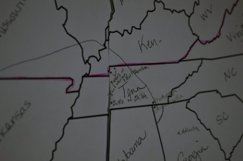
Our curriculum has geography work in it every week, so I use that as a guideline, but it really is easy to do this with any curriculum. For instance, if you are learning about missionaries (see this post for a great missionary study!), you can find where that missionary served on the map. If you are studying the Civil War, you can map all the battles. If you are studying Ancient World History, you can map the Israelites 40 years of wandering. Use different colors and be sure to label!
I want to interject something here that can be super beneficial to you when it comes to mapwork. Have your children take turns searching out geographical information and locations, and sharing that information with your other children! I call this the Learn-Teach-Learn Method, and I talk a lot about it in my book, Large Family Homeschooling. <– click to learn more

#4 – Look for opportunities to refer to the map in your every day discussions.
When you watch the news, when you read a book, when you hear about a certain country at church, when you plan a vacation – REFER TO THE MAP! When the maps are readily accessible, you can easily do this. I also highly recommend you keep a globe of some sorts in the house. The blow up kind are fun for the younger crowd, but I’d encourage you to get a quality “real” globe for a more detailed hands-on experience.
#5 – Don’t be afraid to get help and acknowledge that you are learning alongside the kids!
I’m not too proud to admit that when my kids do mapwork, I am right alongside them, looking it all up online. Google images are great for this! If you are quick and savvy enough, you can look up the information AS you teach, and relay it to the kids as you go. (side note: we recently purchased Apple TV so I can mirror my computer screen onto our television. In the video, I talked about turning the computer screen and passing it around so everyone can see. Being able to mirror the screen makes this so much easier!)
Don’t be afraid to admit to your kids you don’t know where certain places are. Don’t be afraid to get into the wonderment of it all! Don’t be afraid to enjoy learning geography alongside your children!
Other resources mentioned in the video:
Current Events for Homeschooled Teens post
Follow Amy Roberts {Raising Arrows}’s board Teaching Geography on Pinterest.
Nola says
This is a great way to teach geography. I try to always point out whatever places we read about in books. I also got a second hand copy of a book that I really like called the Ultimate Geography and Timeline Guide. I picked it up for $5 not knowing if it would be useful. I find it really makes geography connect across the curriculum. It could be a bit overwhelming at first but its meant for all the grades in one book and there is a section explaining what to do when. Overall I really like it. There are lots of maps in there too.
Amy says
That sounds like a really neat book! I’ll have to check into that!
Natalie says
We use Mega Maps too, I love that you can print out so many different sections of the world in different sizes, and that one version of the world map already has the ocean colored blue. We’ve had ours on the kitchen wall for about 18 months now, and it’s suffered a little wear ‘n’ tear…with the toddler/preschoolers deciding to add giant crayon volcanoes in the middle of the pacific ocean! We like to color in countries that we or people we know have visited, or that our ancestors came from.